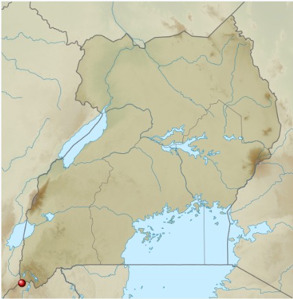
Mgahinga Gorilla National Park is located in the extreme southwestern corner of Uganda, within Kisoro District, where the country meets Rwanda and the Democratic Republic of Congo. The park lies within the Virunga Massif, a chain of volcanic mountains that stretches across three countries and forms part of the western branch of the East African Rift Valley system. This strategic location makes Mgahinga not only a national treasure but also a key component of a larger transboundary ecosystem linked to Virunga National Park and Volcanoes National Park.
The park covers an area of 33.7 square kilometers, making it the smallest national park in Uganda, yet one of the most topographically dramatic. Its altitude ranges from 2,227 meters to 4,127 meters above sea level, resulting in steep gradients, rugged terrain, and rapidly changing climatic conditions. The surrounding landscape includes notable features such as Lake Mutanda and the highlands of Kabale, creating a scenic mosaic of volcanic peaks, valleys, and water bodies that define the region’s geography.
Mgahinga lies within the Virunga volcanic range, one of Africa’s most geologically significant mountain systems. This range consists of a chain of volcanoes formed along the Albertine Rift, a segment of the East African Rift Valley, where tectonic forces are slowly pulling the African continent apart. The Virunga volcanoes were formed during the Pleistocene epoch, roughly between 2.5 million and 12,000 years ago, through repeated volcanic eruptions that deposited layers of lava, ash, and volcanic debris.
The three volcanoes within Mgahinga—Mount Sabyinyo, Mount Gahinga, and Mount Muhabura—represent different stages of volcanic evolution. These volcanoes are classified as stratovolcanoes, meaning they were built up over time by alternating layers of hardened lava and pyroclastic material. Although they are now considered extinct or dormant, their geological structure provides valuable insight into the volcanic history of the entire Virunga region.
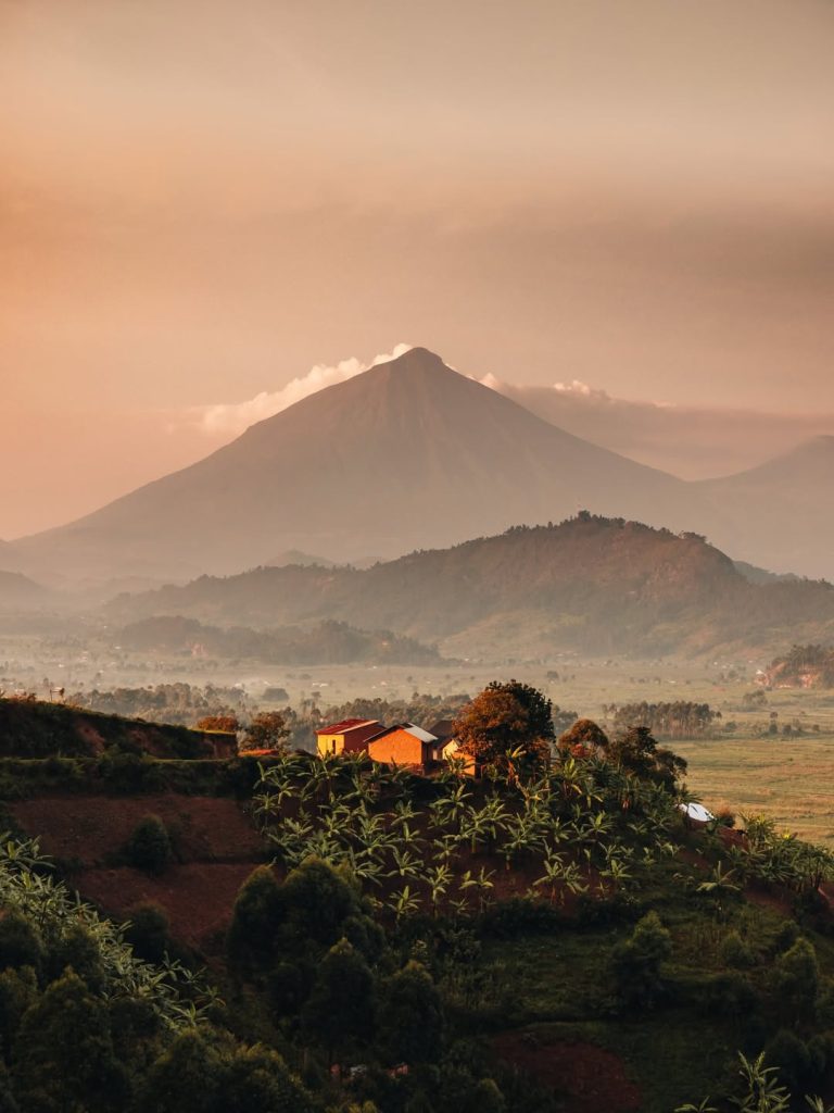
Mount Sabyinyo is the oldest of the three volcanoes and is characterized by its deeply eroded summit, which forms a jagged ridge resembling worn-out teeth—hence its name, derived from a local word meaning “old man’s teeth.” Over time, erosion has carved out steep ridges and valleys, making it one of the most rugged and challenging peaks to climb. Its weathered appearance provides evidence of its great age and long exposure to natural forces.
Geologically, Sabyinyo has undergone significant erosion due to rainfall, landslides, and tectonic activity. The breakdown of its volcanic rock has contributed to fertile soils in the surrounding areas, supporting both vegetation and agriculture. Its slopes also mark the intersection of three countries, making it a unique geographical landmark in Africa.
Mount Gahinga is smaller and less rugged compared to Sabyinyo, but it features a distinctive swamp-filled crater at its summit, approximately 180 meters in diameter. The name “Gahinga” comes from the local term for piles of volcanic stones cleared from farmland, reflecting the mountain’s geological composition and its influence on local livelihoods.
This volcano is geologically younger than Sabyinyo and has retained more of its original shaped structure. The crater swamp is a result of volcanic subsidence and water accumulation, and it plays an important role in the park’s hydrology. The surrounding bamboo forests thrive on the volcanic soils, which are rich in minerals derived from past eruptions.
Mount Muhabura is the tallest and youngest of the three volcanoes in Mgahinga. It has a near-perfect cone shape, indicating relatively recent geological formation compared to the other peaks. At its summit lies a small crater lake, approximately 36 meters in diameter, formed by rainwater accumulation.
The mountain is composed largely of basaltic lava and other volcanic rock types. Its steep slopes and symmetrical structure make it one of the most visually striking features in the Virunga range. Muhabura’s elevation also creates distinct vegetation zones, contributing to the park’s ecological diversity.
The geology of Mgahinga is dominated by volcanic rocks, including basalt, lava flows, ash deposits, and pyroclastic materials. These were formed through repeated volcanic eruptions over thousands of years. As molten lava cooled, it hardened into rock layers, while ash and finer particles settled to form fertile soils.
The park also contains lava tubes and caves, created when the outer layer of flowing lava cooled and solidified while molten lava continued to flow beneath it. When the inner lava drained away, it left hollow tunnels. These geological features provide insight into past volcanic activity and contribute to the park’s unique landscape.
The soils in Mgahinga are derived from volcanic ash and lava, making them highly fertile and rich in minerals. These soils support diverse vegetation, from dense montane forests to bamboo zones and alpine plant communities. However, the steep terrain and heavy rainfall make them vulnerable to erosion.
Over time, natural processes such as weathering, erosion, and vegetation growth have shaped the landscape into its present form. Valleys have deepened, slopes have softened, and plant life has gradually covered much of the volcanic terrain. This continuous interaction between geology and the environment makes Mgahinga a dynamic and evolving ecosystem.
Understanding the geography and geology of Mgahinga Gorilla National Park enhances the visitor experience by revealing the natural forces behind its landscapes. The dramatic volcanoes, fertile valleys, and unique ecosystems are all products of ancient volcanic activity and tectonic movement.
For visitors, Mgahinga is more than just a destination for gorilla trekking—it is a living geological landscape shaped over millions of years. From climbing extinct volcanoes to exploring lava-formed terrain, the park offers a rare opportunity to experience the powerful geological history of the East African region.